Chris Roams
Travel, Adventures, and Photography
Lots of Sierra, Not Much Nevada
January 02, 2012
Sierra Nevada is Spanish for “Snowy Mountain Range”. The highest range in the lower 48 states, it is 400 miles long, 65 miles wide, and for most of its length is generally accepted to be impassable in the winter, in fact a 200 mile long stretch of this range has no road crossings at all. The Tioga Pass Road is the highest elevation crossing of the range at 9,943 feet and is normally buried under snow and subject to avalanches from November through May, but this is no normal winter: it hasn’t snowed here since November and Tioga Pass was open on New Years Day. I couldn’t pass this opportunity up.
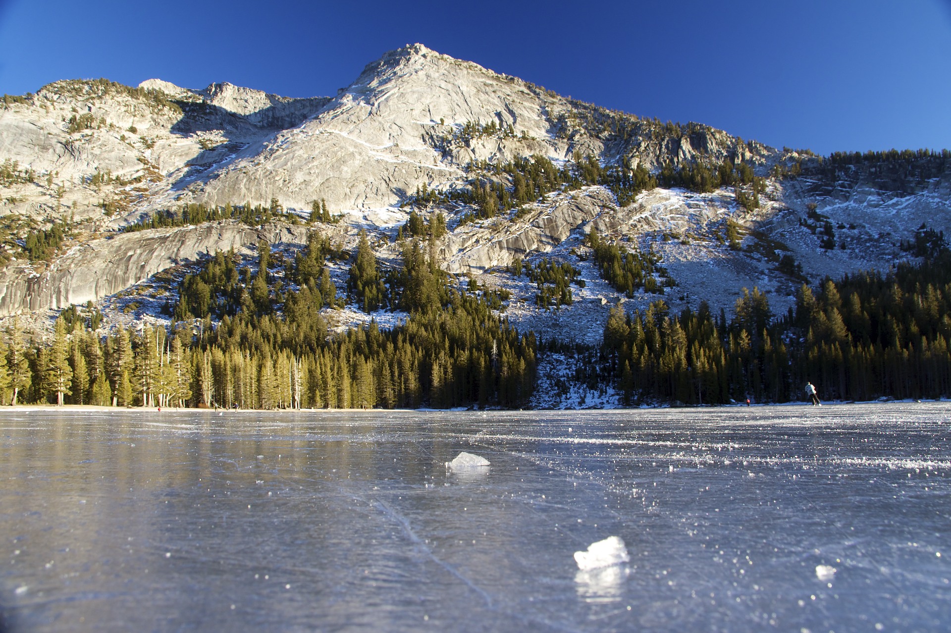
The High Sierra is a wonderful place, solid granite domes carved and polished by glaciers, vast alpine meadows, enormous trees, and crystal clear mountain lakes. Tuolumne Meadows, at 8,619′ had not much more than a few sparse patches of snow, even the high peaks around the meadow were mostly snow-free. It would be easy to mistake it for early summer up here, except for the ice skaters on Tenaya Lake.
Unfortunately I couldn’t spend too much time up high. In spite of the sunny forecast the NPS has a “no overnight parking” rule in effect along the road for the duration of the winter. It’s just as well, after all this is the range where the Donner Party got trapped by snow and resorted to cannibalism, and that was only at 7,000′, in November. I moved on as the sun went down and spent the night down at a more reasonable 4,000′ in the confines of Yosemite Valley with all of the other tourists.
Most of the campgrounds in the Yosemite frontcountry have been turned into the typical NPS gravel Winnnebago parking lots but there is one walk-in relic left over from the old days: Camp 4, sitting near the base of Yosemite Falls. I jumped at the opportunity to get away from the RV crowd and their generators. I don’t know why each national park doesn’t have a tent-only walk-in campground, or at least a designated area off in the corner for tents. The park service even wanted to bulldoze this one and build employee dormitories here back in the 1990′s but a legal battle resulted in the camp itself being listed on the National Register of Historic Places in 2003, preventing the dormitories and preserving it as it is; Camp 4 isn’t just an ordinary campground, this place was the incubator for modern big-wall rock climbing technique.
Camp 4 opened in 1941 and after World War II climbers started staying here, often for longer than regulations allowed for, becoming the climbing equivalent of surf bums known as “dirtbags”. New techniques and equipment were invented to attack the enormous granite walls of Yosemite resulting in first ascents of many of the classic climbs. John Salathé would designed hardened steel pitons (rumored to be forged from the axle of a Model A Ford) that could handle the hard Yosemite granite. The company that is now Black Diamond Equipment started with Yvon Chouinard selling his own home-made pitons designed especially for Yosemite’s cracks out of the trunk of his car in the parking lot of Camp 4. Choinard (also the founder of the wildly successful Patagonia clothing company) and Tom Frost would go on to invent the Hexentric while Ray Jardine invented the SLCD, all pieces of gear that enabled modern “clean climbing” technique that doesn’t require scarring the rock with pitons. The standard of performing big-wall climbs in one continuous push instead of using fixed-line siege tactics was set here in 1960 when a team including Royal Robbins, Tom Frost, and Chuck Pratt completed The Nose on El Capitan in 7 days with no fixed ropes, the first ascent using siege tactics had taken Warren Harding’s team 45 days only 3 years earlier. By 1970 the climbers, techniques, and gear developed here were the best in the world and were spreading out across it; today the world comes here to stay in Camp 4 and climb where these legends started it all. There were certainly plenty of climbers racking up gear and heading out to enjoy the spring-like conditions when I left in the morning.
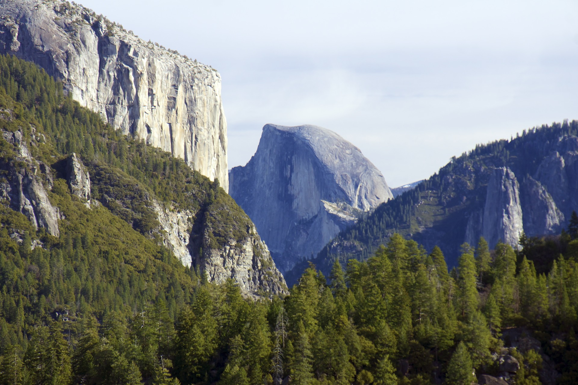
The usual state of things is that the temperature gets colder as elevation increases so logic would dictate that the Yosemite Valley should be warmer than the ridges above but this isn’t always the case: when the sun goes down and stops heating the ground dense air cooled by high mountain snow can pour down like water to pool up in the valleys. One of the joys of motorcycles is being exposed to the environment (for better or worse) and although the crazy motorcycle suit I’ve been wearing keeps me plenty warm it is still possible to feel the temperature changes going on outside, like putting a hand near a cold window in a warm room. Compared to Death Valley I woke up to a colder-than-usual morning on the floor of Yosemite Valley and after puttering around the valley looking for breakfast and taking pictures I finally hopped on the bike and took the Big Oak Flat road out. Only a few hundred feet up off the valley floor it was like punching through an invisible ceiling into a warm attic, going from a chilly spring morning (because it certainly doesn’t feel like winter out here) to an early summer day.
These rivers of cold, moist air are the key to another of the the Sierra’s treasures: the Giant Sequoias. They are not the tallest trees (the Coastal Redwoods have them beat there) or the oldest (Bristlecone Pines) but the they are the biggest with the record-holder 275′ tall, 102′ around, and estimated to weigh 2,100 tons. The trees have very specific moisture requirements and the scattered groves grow only at certain elevations in the valleys on the western flank of the range where they can absorb the moisture pouring down from above. The story of the Sequoias and these forests in general are an example of misguided attempts to protect them. Despite what Smokey the Bear may tell you the most common cause of forest fires in the United States is lightning and throughout history these forests would burn every few decades but the Sequoias’ 3 foot thick bark would protect them; indeed many of these trees show ancient burn scars. As settlers moved in wildfires were seen as a threat, both to settlements and the forests themselves, and great efforts have been made to stop them whenever they start. After a few centuries of fire suppression efforts the forest floor has become littered with massive amounts of dead wood, much more fuel than would have been available when the forests burned regularly. Now when wildfires start this excess fuel can make them nearly unstoppable and allow them to burn hot enough to destroy even the mighty Sequoias. In the past biologists used the think the Sequoias were a species headed for extinction as there were no young trees in the forest, we’ve also now realized that the burning process is an essential part of the Sequoia’s lifecycle, its cones only open to drop their seeds after they (and by extension all of the competing plants on the forest floor) have been burned. By preventing the reproduction of the trees and providing a sufficient fuel stockpile to destroy mature trees the act of fire suppression, initial undertaken to protect them, presents a double threat to the species. Today rangers and the fire departments intentionally set forest fires (when the conditions are appropriate) to simulate the natural burning process that has been inhibited for so long and restore the forest to its natural state.
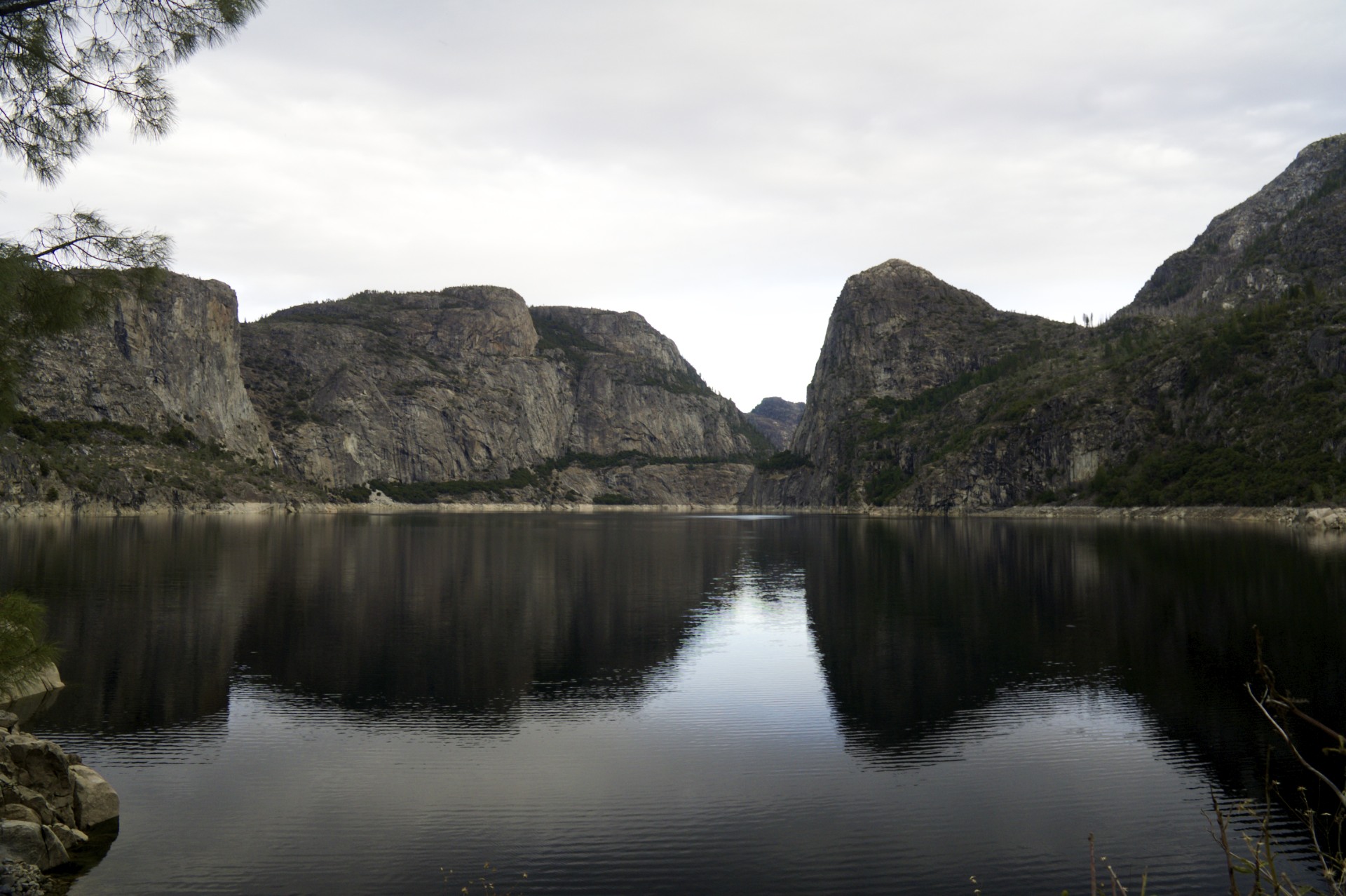
Hidden away in a corner of the park (to reach it one must actually leave the park and re-enter via a different route) is another one of Yosemite’s secrets: Hetch Hetchy. This is another broad valley surrounded by high granite cliffs sprouting majestic waterfalls with the Tuolumne River snaking across the meadows on the valley floor, very similar to Yosemite Valley itself, or rather it was before a dam was placed across it. Now the meadows sit under 300 feet of water that spans the valley from one granite wall to the other, a reservoir for the city of San Francisco built inside a national park. Not many tourists come here, there is just a long lonely road leading to a parking lot and backpacker’s camp for hikers heading into the backcountry. I can’t say I blame them either, this place just doesn’t look right with an enormous concrete wall and the bleached “bathtub ring” marring the rock that all of these reservoirs seems to have. John Muir personally opposed this dam and the Sierra Club that he founded that had been instrumental in getting Yosemite declared a national park fought against the dam’s construction but failed, barely 50 years after Abraham Lincoln signed legislation setting aside Yosemite with the words “inalienable for all time” a dam was being built inside the boundaries of national park. In an odd twist of politics both the Reagan and Bush (the second) administrations looked into removing the dam and restoring the valley to its natural state but received opposition from Dianne Feinstein, the Democrat mayor of San Francisco during Reagan’s administration and a California Senator during Bush’s administration. While California and especially San Francisco Democrats generally tend to support all things “green” I suppose politics goes out the window when it’s one’s own water supply that is being threatened.
Speaking of threatened water, I don’t know what is going on with the winter this year. Not only should I not have been able to drive right across the center of the Sierras, but many of the high elevation roads I’ve been on in the Death Valley area (Cerro Gordo, Aguereberry Point, Leadfield) should have significant snow cover by now. While I am thankful for the opportunity to see so many of these places at this wonderful time of year with relatively little hassle I worry about the water supplies for next season. Most of these reservoirs: Hetch Hetchy, Lake Powell, Lake Mead, and the water that Los Angeles is pumping out from under Owens Lake; are recharged from snowmelt. If there’s no snow to melt there won’t be any recharge in the spring. As the bathtub rings on Lake Mead a few weeks ago attest these regions have been in a serious drought for years and have already been drawing more water out of their reservoirs than nature has been putting back in. Last winter’s record snowpack was a bit of a relief but didn’t come close to refilling the supplies along the Colorado River. As I came down from Yosemite and checked into civilization in the former gold fields of California I saw news bulletin that they were tapping the reservoir to fill the irrigation canals in the San Joaquin Valley (normally unused in the winter) so farmers can water their crops. If there’s no water left this summer and the taps in Las Vegas, Los Angeles, and San Francisco threaten to run dry I wonder where they will go to look for it next. I hear there’s plenty of good water in Lake Tahoe.


The High Sierra is a wonderful place, solid granite domes carved and polished by glaciers, vast alpine meadows, enormous trees, and crystal clear mountain lakes. Tuolumne Meadows, at 8,619′ had not much more than a few sparse patches of snow, even the high peaks around the meadow were mostly snow-free. It would be easy to mistake it for early summer up here, except for the ice skaters on Tenaya Lake.
Unfortunately I couldn’t spend too much time up high. In spite of the sunny forecast the NPS has a “no overnight parking” rule in effect along the road for the duration of the winter. It’s just as well, after all this is the range where the Donner Party got trapped by snow and resorted to cannibalism, and that was only at 7,000′, in November. I moved on as the sun went down and spent the night down at a more reasonable 4,000′ in the confines of Yosemite Valley with all of the other tourists.
Most of the campgrounds in the Yosemite frontcountry have been turned into the typical NPS gravel Winnnebago parking lots but there is one walk-in relic left over from the old days: Camp 4, sitting near the base of Yosemite Falls. I jumped at the opportunity to get away from the RV crowd and their generators. I don’t know why each national park doesn’t have a tent-only walk-in campground, or at least a designated area off in the corner for tents. The park service even wanted to bulldoze this one and build employee dormitories here back in the 1990′s but a legal battle resulted in the camp itself being listed on the National Register of Historic Places in 2003, preventing the dormitories and preserving it as it is; Camp 4 isn’t just an ordinary campground, this place was the incubator for modern big-wall rock climbing technique.
Camp 4 opened in 1941 and after World War II climbers started staying here, often for longer than regulations allowed for, becoming the climbing equivalent of surf bums known as “dirtbags”. New techniques and equipment were invented to attack the enormous granite walls of Yosemite resulting in first ascents of many of the classic climbs. John Salathé would designed hardened steel pitons (rumored to be forged from the axle of a Model A Ford) that could handle the hard Yosemite granite. The company that is now Black Diamond Equipment started with Yvon Chouinard selling his own home-made pitons designed especially for Yosemite’s cracks out of the trunk of his car in the parking lot of Camp 4. Choinard (also the founder of the wildly successful Patagonia clothing company) and Tom Frost would go on to invent the Hexentric while Ray Jardine invented the SLCD, all pieces of gear that enabled modern “clean climbing” technique that doesn’t require scarring the rock with pitons. The standard of performing big-wall climbs in one continuous push instead of using fixed-line siege tactics was set here in 1960 when a team including Royal Robbins, Tom Frost, and Chuck Pratt completed The Nose on El Capitan in 7 days with no fixed ropes, the first ascent using siege tactics had taken Warren Harding’s team 45 days only 3 years earlier. By 1970 the climbers, techniques, and gear developed here were the best in the world and were spreading out across it; today the world comes here to stay in Camp 4 and climb where these legends started it all. There were certainly plenty of climbers racking up gear and heading out to enjoy the spring-like conditions when I left in the morning.
The usual state of things is that the temperature gets colder as elevation increases so logic would dictate that the Yosemite Valley should be warmer than the ridges above but this isn’t always the case: when the sun goes down and stops heating the ground dense air cooled by high mountain snow can pour down like water to pool up in the valleys. One of the joys of motorcycles is being exposed to the environment (for better or worse) and although the crazy motorcycle suit I’ve been wearing keeps me plenty warm it is still possible to feel the temperature changes going on outside, like putting a hand near a cold window in a warm room. Compared to Death Valley I woke up to a colder-than-usual morning on the floor of Yosemite Valley and after puttering around the valley looking for breakfast and taking pictures I finally hopped on the bike and took the Big Oak Flat road out. Only a few hundred feet up off the valley floor it was like punching through an invisible ceiling into a warm attic, going from a chilly spring morning (because it certainly doesn’t feel like winter out here) to an early summer day.
These rivers of cold, moist air are the key to another of the the Sierra’s treasures: the Giant Sequoias. They are not the tallest trees (the Coastal Redwoods have them beat there) or the oldest (Bristlecone Pines) but the they are the biggest with the record-holder 275′ tall, 102′ around, and estimated to weigh 2,100 tons. The trees have very specific moisture requirements and the scattered groves grow only at certain elevations in the valleys on the western flank of the range where they can absorb the moisture pouring down from above. The story of the Sequoias and these forests in general are an example of misguided attempts to protect them. Despite what Smokey the Bear may tell you the most common cause of forest fires in the United States is lightning and throughout history these forests would burn every few decades but the Sequoias’ 3 foot thick bark would protect them; indeed many of these trees show ancient burn scars. As settlers moved in wildfires were seen as a threat, both to settlements and the forests themselves, and great efforts have been made to stop them whenever they start. After a few centuries of fire suppression efforts the forest floor has become littered with massive amounts of dead wood, much more fuel than would have been available when the forests burned regularly. Now when wildfires start this excess fuel can make them nearly unstoppable and allow them to burn hot enough to destroy even the mighty Sequoias. In the past biologists used the think the Sequoias were a species headed for extinction as there were no young trees in the forest, we’ve also now realized that the burning process is an essential part of the Sequoia’s lifecycle, its cones only open to drop their seeds after they (and by extension all of the competing plants on the forest floor) have been burned. By preventing the reproduction of the trees and providing a sufficient fuel stockpile to destroy mature trees the act of fire suppression, initial undertaken to protect them, presents a double threat to the species. Today rangers and the fire departments intentionally set forest fires (when the conditions are appropriate) to simulate the natural burning process that has been inhibited for so long and restore the forest to its natural state.
Hidden away in a corner of the park (to reach it one must actually leave the park and re-enter via a different route) is another one of Yosemite’s secrets: Hetch Hetchy. This is another broad valley surrounded by high granite cliffs sprouting majestic waterfalls with the Tuolumne River snaking across the meadows on the valley floor, very similar to Yosemite Valley itself, or rather it was before a dam was placed across it. Now the meadows sit under 300 feet of water that spans the valley from one granite wall to the other, a reservoir for the city of San Francisco built inside a national park. Not many tourists come here, there is just a long lonely road leading to a parking lot and backpacker’s camp for hikers heading into the backcountry. I can’t say I blame them either, this place just doesn’t look right with an enormous concrete wall and the bleached “bathtub ring” marring the rock that all of these reservoirs seems to have. John Muir personally opposed this dam and the Sierra Club that he founded that had been instrumental in getting Yosemite declared a national park fought against the dam’s construction but failed, barely 50 years after Abraham Lincoln signed legislation setting aside Yosemite with the words “inalienable for all time” a dam was being built inside the boundaries of national park. In an odd twist of politics both the Reagan and Bush (the second) administrations looked into removing the dam and restoring the valley to its natural state but received opposition from Dianne Feinstein, the Democrat mayor of San Francisco during Reagan’s administration and a California Senator during Bush’s administration. While California and especially San Francisco Democrats generally tend to support all things “green” I suppose politics goes out the window when it’s one’s own water supply that is being threatened.
Speaking of threatened water, I don’t know what is going on with the winter this year. Not only should I not have been able to drive right across the center of the Sierras, but many of the high elevation roads I’ve been on in the Death Valley area (Cerro Gordo, Aguereberry Point, Leadfield) should have significant snow cover by now. While I am thankful for the opportunity to see so many of these places at this wonderful time of year with relatively little hassle I worry about the water supplies for next season. Most of these reservoirs: Hetch Hetchy, Lake Powell, Lake Mead, and the water that Los Angeles is pumping out from under Owens Lake; are recharged from snowmelt. If there’s no snow to melt there won’t be any recharge in the spring. As the bathtub rings on Lake Mead a few weeks ago attest these regions have been in a serious drought for years and have already been drawing more water out of their reservoirs than nature has been putting back in. Last winter’s record snowpack was a bit of a relief but didn’t come close to refilling the supplies along the Colorado River. As I came down from Yosemite and checked into civilization in the former gold fields of California I saw news bulletin that they were tapping the reservoir to fill the irrigation canals in the San Joaquin Valley (normally unused in the winter) so farmers can water their crops. If there’s no water left this summer and the taps in Las Vegas, Los Angeles, and San Francisco threaten to run dry I wonder where they will go to look for it next. I hear there’s plenty of good water in Lake Tahoe.
- Acadia National Park
- Adirondacks
- Aerial
- Airstream
- Ancient Bristlecone Pines
- Anza-Borrego
- Appalachian Trail
- Arches National Park
- Backpacking
- Bad Larry
- Bears Ears National Monument
- Boatpacking
- Boston
- Bryce Canyon National Park
- Canoeing
- Canyon de Chelly National Park
- Canyoneering
- Canyonlands National Park
- Capitol Reef National Park
- Caribbean
- Catskills
- Cities
- Climbing
- Colorado National Monument
- Colorado Plateau
- Death Valley National Park
- Europe
- Fisher Towers
- Grand Canyon National Park
- Grand Staircase-Escalante National Monument
- Grand Teton National Park
- Gunks
- Hiking
- Iceland
- Joshua Tree National Park
- Lassen Volcanic National Park
- Manzanar National Historic Site
- Mojave Desert
- Mojave National Preserve
- Mountaineering
- Mt Washington
- Mt Whitney
- Natural Bridges National Monument
- New York CIty
- Pacific Northwest
- Petrified Forest National Park
- Pinnacles National Monument
- Red Roamer
- Road Trips
- Rocky Mountains
- Ruins
- Sailing
- San Diego
- San Francisco
- Sequoia National Park
- Sierra Nevada
- Skiing
- Sonora Desert
- Spelunking
- Superbloom
- Superstition Mountains
- White Mountains
- Yellowstone National Park
- Yosemite National Park
- Zion National Park
